VAUGHAN, Ontario, Feb. 06, 2018 (GLOBE NEWSWIRE) --
Teledyne Optechs
Titan sensor was used by the University of Houstons National Center for Airborne Laser Mapping (NCALM) to reveal extensive Mayan ruins in Guatemala. Lidar technology was able to identify hundreds of previously unknown structures, including raised highways, and complex irrigation and terracing systems.
 |
|
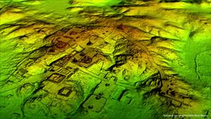
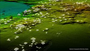
The Optech Titan stripped away overlying vegetation to reveal extensive Mayan ruins in Guatemalas rainforest. |
|
 |
|
The Optech Titan stripped away overlying vegetation to reveal extensive Mayan ruins in Guatemalas rainforest. |
|
|
After the collapse of the Mayan civilization, their cities and monuments were quickly covered by thick rainforest, hiding the ancient civilization from airborne observation and making it very difficult to survey on foot. Flying high above the rainforest, the Titans lasers penetrated the canopy to collect almost a million data points per second from the forest floor, giving archaeologists a bare earth view of the structures underneath. Having covered 2,100 km
2, the Titans data revealed massive amounts of ruins hidden below the forest, showing that their urban centers were significantly larger than archaeologists had previously thought.
We are incredibly proud and excited that our award winning Titan multispectral lidar sensor has contributed to this spectacular discovery, said Michel Stanier, EVP and General Manager of Teledyne Optech. The Titans ability to strip away overlying vegetation and map wide areas very quickly and accurately makes it an important tool for archaeologists, and we expect to see many more discoveries coming from it and our other airborne laser terrain mappers.
The Optech Titan is the first commercial multi-spectral lidar sensor to incorporate 3 independent laser wavelengths into a single sensor design, with beams at 532, 1064, and 1550 nm (0.5/1.0/1.5 microns) and a ground sampling rate of 300 kHz per beam. Because Titan uses both green and infrared channels, it is capable of simultaneous water depth mapping and high-precision 900-kHz topography. Titan can also be used for purposes such as vegetative and forestry applications, which require multiple wavelengths for improved classification accuracy and carbon credit counting initiatives.
As featured in National Geographics Lost Treasures of the Maya Snake Kings, more information about which can be found at
www.natgeotv.com. Find out more at
www.teledyneoptech.com
About Teledyne OptechTeledyne Optech is the world leader in high-accuracy lidar 3D survey systems, integrated cameras, and productivity-enhancing workflows. With operations and staff worldwide, Teledyne Optech offers both standalone and fully integrated lidar and camera solutions for airborne mapping, airborne lidar bathymetry, mobile mapping, terrestrial laser scanning, mine cavity monitoring, and industrial process control, as well as space-proven sensors. Teledyne Optech supports its clients with an around-the-clock team, on-site service, and regular efficiency enhancements to the workflow of its integrated systems. Accuracy and productivity matter!
Photos accompanying this announcement are available at
http://www.globenewswire.com/NewsRoom/AttachmentNg/e8d3ebaf-2629-4295-a5e1-4ca140eb1cac and
http://www.globenewswire.com/NewsRoom/AttachmentNg/a4695edf-3ff1-4a4f-bb47-26bb74eaa2e1
For further information, please contact your Regional Sales Manager or: